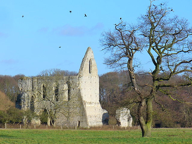
Newark Priory
Pyrford Green, Surrey
|

Quick Guide
See below grid for details |
Today a ruined priory located in a meadow
adjacent to Newark Lane, in the village of Pyrford in Surrey. It is on private
land so it is not possible to get up close, but pictures can be taken across the
fields, from the lane.
Ruined Augustinian building, founded in 12th
Century by Ruald de Calva and wife, Beatrice de Saudes for Augustian canons. The
Priory's name changed over the years to Newstead and then finally Newark. It was
dissolved during the period of the Dissolution of the Monasteries by King Henry
VIII. The prior itself was pensioned off and it's valuables sent to the Tower of
London, the land was given to the Master of the Kings Horse. The last known
prior of Newark Priory was Richard Lipscombe, appointed just before the
surrender of the house in 1538. It then fell into ruin.

Taken December 2007
 Colin Smith

Nearby is the River Wey Navigation which
connects Godalming and Guildford to Weybridge on Thames. There is a 20 mile
tow path which is flat and at Pyrford there is Newark Lock, next to the
Anchor Pub. The Wey Navigation is owned by the National Trust and they
provide various car parks along it at different points and this may be the
car park shown on the maps near the Priory. You may be able to get photos
from the tow path, although from the aerial maps there are trees in the way,
but they do seem to have breaks in them, however you may need a good
telephoto zoom to get the distance. See this
link on the walkthisway.co.uk website
 to find details of a walk and a picture of the
Priory taken from the towpath.
|
Location: Newark Priory, Pyrford, Surrey |
|
Grid Reference: TQ041576 |
Ceremonial County:
Surrey
 |
|
Map Link:
StreetMap

|
Aerial photo:
Google Aerial Photo

|
|
Getting there: Coming out of the village on
the B367 the Priory is on your left, just past over the river there is a car
park on the right hand side. From A3 take the B2215 to Ripley and then left
onto the B367 (Newark Lane), the priory is on the right after the car park. |
|
Access: On private land so no close up access
possible, however there is a public footpath and a towpath nearby so may be
able to get shots from here as well as the road side. |
|
Website: |
|
Other Useful Websites:
Wiki
 British History Online
 River Wey Navigations


Pyrford History
 |
|
Email: |
|
Address: |
|
Postcode: |
Telephone: |
|
Opening Times: Any reasonable daylight time |
|
Charges: None |
|
Nearby Locations: |
Other Location Pages:
Abbey Section
 |
|
Notes:
|
|

|
This page is a Quick Guide, the idea of Quick
Guides is to allow very basic information and linking forward information to be
added to the system rather than having to wait until a full location guide has
been developed. It should therefore be considered a development stage rather
than a finished objective. Once more information is known the objective is to
create either a Location or Featured Location page which has two grids and far
more information.
Please let us know any other information that we
can add to the Grid(s) or page and any errors that you discover. Before making a long trip to any location it is always
wise to double check the current information, websites like magazines may be
correct at the time the information is written, but things change and it is of
course impossible to double check all entries on a regular basis. If you have
any good photographs that you feel would improve the illustration of this page
then please let us have copies. In referring to this page it is helpful if you
quote both the Page Ref and Topic or Section references from the Grid below. To print the
planning grid select it then right click and print the selected area.
Please submit information on locations you discover so
that this system continues to grow.
|