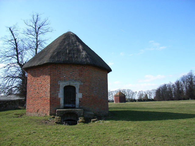
Ascott Park Dovecote
Stadhampton, Oxfordshire
|

Location Guide |
Situated
100 metres northwest of
Ascott Park Farmhouse, in a field that once used to be Ascott Park, sits
2
octagonal brick built buildings. One is thatched and used to be an ice
house with a granary above. The other is a 16th century dovecote with a
tiled roof and circular interior.
The dovecote is
a single storey building, octagonal in plan constructed of red brick with
diapers of vitrified headers and with a plain tile roof. The walls
have a corbel table of moulded bricks forming trefoiled arches, grey
vitrified headers form patterns of horizontal zig-zag, diaper and
Flemish-bond chequer on wall surfaces below. The doorway and 3-light
casements are later insertions. The roof has 4 small dormer openings and a
low central cupola.
Inside the structure is circular and the walls
have tiers of nesting boxes. The roof has butt purlins and is probably largely
original.
Ascott Park once housed a substantial manor
house which existed on the site in the 1600's, it was damaged in 1642, re-built
in 1660, burnt down in 1662 and rebuilt again. It was used as a dower house
until at least 1728, but disappered in the early 19th century with the park and
most of the gardens now pasture land or woodland for nearby Ascott Park Farm.
Although that remains or the original as an earthworks of the formal gardens and
park and these two structures originally formed part of the formal gardens of
Ascott Park.
It is not open to the public by a pubic foot
path, Shakespear's Way, runs through the park close by. They can be seen from
the road, through the hedges, but also there is a lane on the right which takes
you to the farm, which also doubles up at part of the local public footpath
system, so you can walk up here and they can be viewed and photographed from
this position.

The thatched structure in the
foreground is the ice house/granary
the structure behind is the dovecote.
 Photo by
Andrew Smith

|
Location: Ascott Park Dovecotes,
Stadhampton, Oxfordshire |
|
Grid Reference:
SU611982 |
Ceremonial County:
Oxfordshire
 |
|
Map Link:
Multimap

|
Aerial photo:
Multimap Aerial
 |
|
Getting there: From M40 take junction 7 onto
A329 to Stadhampton. Just past the church take the B480 to Chalgrove and
Ascott Park is along on the right hand side. |
|
Access: No public access to dovecote but the
Shakespeare's Way Footpath runs through the park close to the Dovecote. |
|
Website: |
|
Other Useful Websites: |
|
Email: |
|
Address: Ascott Park, Stadhampton, Oxfordshire |
|
Postcode: OX44 7UJ |
Telephone: |
|
Opening Times: Any reasonable time |
|
Charges: None |
|
Nearby Locations: |
|
Other Location Pages: |
|
Other Relevant Pages: Dovecots
 Dovecots
in England
 Dovecots
in Wales

Doocots in
Scotland

|
|
Notes:
|
|

|
Please let us know any other information that we
can add to the Grid(s) or page and any errors that you discover. Before making a long trip to any location it is always
wise to double check the current information, websites like magazines may be
correct at the time the information is written, but things change and it is of
course impossible to double check all entries on a regular basis. If you have
any good photographs that you feel would improve the illustration of this page
then please let us have copies. In referring to this page it is helpful if you
quote both the Page Ref and Topic or Section references from the Grid below. To print the
planning grid select it then right click and print the selected area.
Please submit information on locations you discover so
that this system continues to grow.
|