| Home | Newsletter | Locations | Diary |
| Indexes |
|
| Travellers Resource |
|
|
|
|
|
Maps |
|
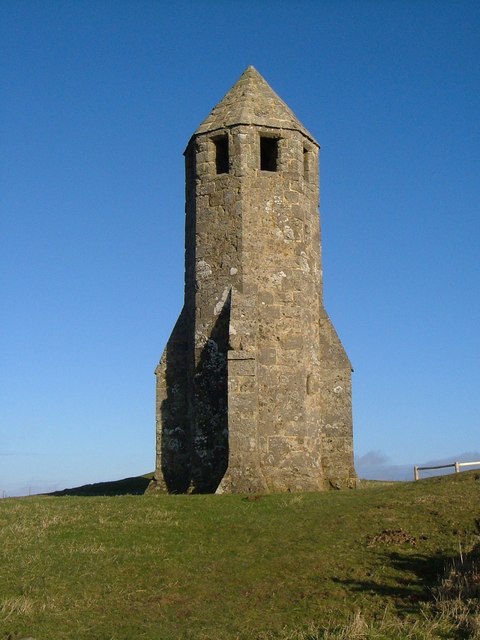
St Catherine's Oratory is known locally as the Pepper Pot, although it looks more like a stone space rocket than a pepper pot, but the name dates from before space was even dreamt of. This early lighthouse has a story. The ship the 'Saint Marie' was wrecked on Atherfield Ledge, in the Parish of Shorwell in 1313/1314. The tower was built as a lighthouse to prevent further wrecks and there was originally an oratory chapel with a monk whose job was to trim the light and say masses for those lost at sea. After the Reformation the church fell into ruins, and had disappeared by the 18th century, but buttresses were added to the tower then to keep it standing as a seamark. Restored by P G Stone in 1891 and by the then Ministry of Works in 1950. The top storey has 8 windows splayed outwards to emit light from the brazier which formed the beacon. Stairs and floors now missing. A rare survival of a medieval lighthouse. Originally there was a chimney opening at the top of the tower. A fire was maintained on the top floor and could be seen through eight openings. It is said to be Britain's oldest medieval lighthouse, although the remains of at least 2 roman lighthouses remain, It is located on the top of St Catherine's Down, the southernmost point of the Isle of Wight. The tower is 35.5ft tall and is over 750ft above sea level. The lighthouse was built by Walter de Godeton, a nearby landowner who was convicted of receiving at least 53 casks of white wine from a ship that had wrecked in the fog on St. Catherine's Point. As punishment, he was ordered to build a lighthouse and an adjoining oratory where priests would say mass for the souls of sailors lost at sea. The lighthouse was apparently in regular operation until Henry VIII closed Catholic religious institutions in 1547. Only foundation ruins remain of the oratory. Located near Chale, about 2km (1.3 mi) north northwest of the St. Catherine's lighthouse. Looking into the legend of why it was built further and we get. In April 1313 the merchant ship St Marie of Bayonee, carrying wine from Tonnay in the Aquitaine region of France, ran aground on Atherfield Ledge in Chale Bay. All the sailors survived and the wine was salvaged by the local islanders. All 174 casks of wine had soon disappeared - the wealthier islanders in the area had gotten hold of most of them. One, Walter de Godeton, who lived in Chale Manor, managed to get the most, and soon had 53 of the casks. The law, though, arrived on the island to try and sort the situation out and Walter de Godeton was caught, charged with illegally receiving the casks and was fined 227.5 marks, just under five marks per cask. The owner of the wine, was the monastery of Livers, in Picardy, France. To have taken their wine was sacrilege. and Walter de Godeton was summoned to the ecclesiastical court in Rome and appeared before the Pope. The Pope told Walter that he would be excommunicated from the church and his soul would be damned to burn in Hell for all eternity, unless he atoned for his sin by building a lighthouse on top of Chale Down to prevent any more shipwrecks, with an oratory for a priest to pray for the souls of those at sea. This Walter de Godeton did, finishing the lighthouse by 1328. It was maintained by monks who lived in a chapel nearby. This continued until Henry VIII's breakaway from the Catholic Church in 1538 and the suppression of the chantries in 1547. With no one to maintain it, the lighthouse was abandoned and the chapel was soon in ruins. Little remains of the chapel today, yet the Pepper Pot itself remains intact. See Also
St
Catherine's Point Lighthouse
Isle of
Wight, Hampshire
Please let us know any other information that we can add to the Grid or page and any errors that you discover. Before making a long trip to any location it is always wise to double check the current information, websites like magazines may be correct at the time the information is written, but things change and it is of course impossible to double check all entries on a regular basis. If you have any good photographs that you feel would improve the illustration of this page then please let us have copies. In referring to this page it is helpful if you quote both the Page Ref and Topic or Section references from the Grid below. To print the planning grid select it then right click and print the selected area. Please submit information on locations you discover so that this system continues to grow.
|
||||||||||||||||||||||||||||||||||||||||||||||||||||
. |
||||||||||||||||||||||||||||||||||||||||||||||||||||
|
||||||||||||||||||||||||||||||||||||||||||||||||||||
|
|