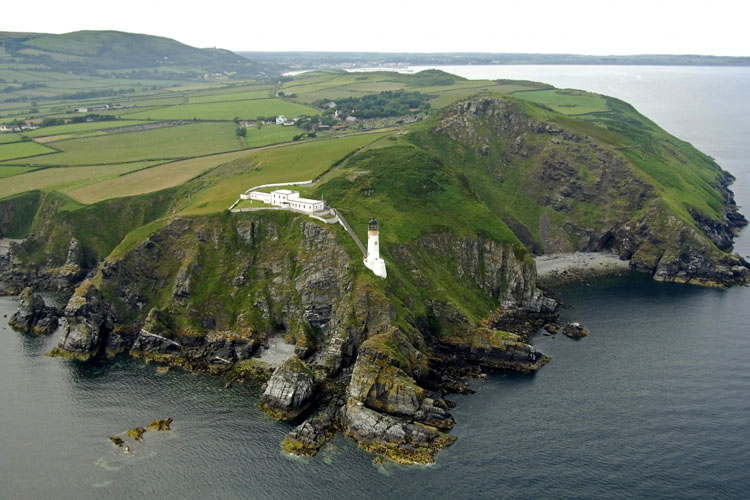
Maughold Head Lighthouse
Isle of Man
|

Location Guide |
Aerial Photo
Marinas.com
 (more images available) (more images available)
In 1909 a suggestion was put forward, as a
result of a complaint from Lord Inverclyde, that the Whitestone Bank Light was
often extinguished and on several occasions shipping had come to grief. There
being no light between Point of Ayre and Douglas Head, it was advised that a
light and fog signal would be of great assistance to shipping. Approval was
originally declined by Trinity House as they had a lightship just 4 miles away.
On its second application, after getting the go ahead from the Board of Trade,
Trinity House had to give their approval for the lighthouse here, and it was
built by Alan Stevenson, and came into operation in 1914.
The lighthouse is perched about half the way
up a steep cliff. The 77 foot tower brings it's light to the same
height as the light keepers houses on the cliff top - some 128 steps above.
Electricity was installed in 1947 and it has a battery back-up system.
The keepers' house accommodated the Principal
and two assistant keepers, and their families. The Principal had the upper floor
of the house, and downstairs was divided into two flats. This and other buildings, located above the lighthouse at the top, have been sold and are now
in private ownership.
One of the lighthouse keepers tells his
Light
Keepers Journey
at Maughold.
|
Lighthouse information Grid
|

|
Please let us know any other information that we
can add to the Grid or page and any errors that you discover. Before making a long trip to any location it is always
wise to double check the current information, websites like magazines may be
correct at the time the information is written, but things change and it is of
course impossible to double check all entries on a regular basis. If you have
any good photographs that you feel would improve the illustration of this page
then please let us have copies. In referring to this page it is helpful if you
quote both the Page Ref and Topic or Section references from the Grid below. To print the
planning grid select it then right click and print the selected area.
Please submit information on locations you discover so
that this system continues to grow.
|