Article
Roman Walls
|
The two features that many think of when you
think of Roman Britain is Roman roads and Roman walls.
The Romans had within their legions excellent
stonemasons. These were able to put stone blocks to fit so tight that hardly any
mortar was required and to shape stone for bridges, arches, aqueducts and
more.
They constructed walled forts, built town walls
and a number of walls to keep out, in or control the flow of people. We have a
number of surviving town walls and many fragments.
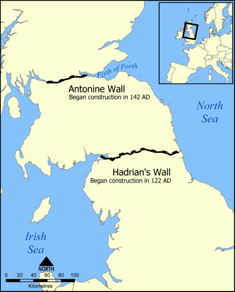
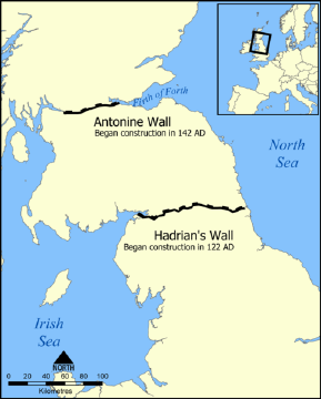
Some of the walls they built within the empire
were very long, and in Britain there were a number of walls built to control the
flow of people, of these Hadrian's Wall and Antonine Wall are the best known.
Hadrian's Wall was 80 Roman miles (73.5
statute miles or 117 kilometres) long, its width and height dependent on the
construction materials which were available nearby. East of River Irthing the
wall was made from squared stone and measured 3 metres (9.7ft) wide and 5-6 metres (16–20ft) high, while west of the river the wall was made from turf
and measured 6 metres (20ft) wide and 3.5 metres (11.5ft) high. This does not
include the wall's ditches, berms, and forts. The central section measured eight
Roman feet wide (7.8ft or 2.4m) on a 10-foot (3.0m) base. Some parts of this
section of the wall survive to a height of 10 feet (3.0m). |

|
The initial design had small mile forts and
turrets between. Later it was decided to add 14 or 17 larger forts along the
wall length, each holding 500 to 1000 auxiliary troops.
| In the years after Hadrian's death in 138, the
new emperor, Antoninus Pius essentially abandoned the wall, leaving it occupied
in a support role, and began building a new wall in Scotland proper, about 160
kilometres (100 miles) north, called the Antonine Wall. This turf wall ran
40 Roman miles (about 37.8 miles (60.8km)) and had significantly more forts than
Hadrian's Wall. Antoninus was unable to conquer the northern tribes, so when
Marcus Aurelius became emperor he abandoned the Antonine Wall and reoccupied
Hadrian's Wall as the main defensive barrier in 164. The wall remained occupied
by Roman troops until their withdrawal from Britain. The Hadrian’s Wall Path is a long
distance footpath in the North of England, which became the 15th National Trail
in 2003. It runs for 84 miles (134.5 kilometres), from Wallsend on the east
coast of Great Britain to Bowness-on-Solway on the west coast. The path runs
through urban areas, and over moors. For most of its length it is close to the
remains of Hadrian's Wall.
|
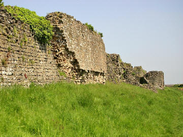
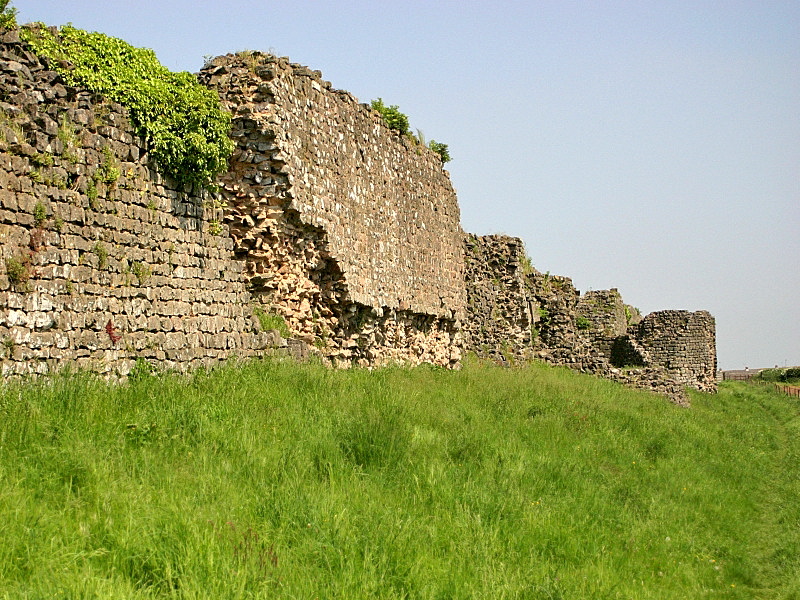
Part of the Town wall of Venta Silurum
(Caerwent, South Wales)

 |
Hadrian's Wall
Forts (links are
al within wikiipedia)
The Latin and Romano-Celtic names of some
of the Hadrian's Wall forts are known, from the
Notitia Dignitatum
and other evidence:
Outpost forts beyond the wall include:
Supply forts behind the wall include:
Antonine Wall and Way
We are working on a more in depth coverage of
Hadrian's Wall and its forts,
which we hope to have available shortly.
|