| Home | Newsletter | Locations | Diary |
|
Indexes |
|
|
|
|
|
|||||||||||||||||||||||||||||||||||||||||||||||||||||||||||||||||||||||||||||||||||||||||||||||||||||||||||||||||||||||||||||||
|
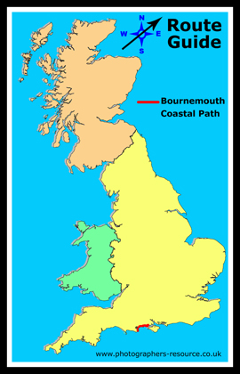
This 37 mile walk takes you from Swanage in
Dorset through to Lymington in Hampshire. It links the Dorset end of the
South
West Coast Path,
The walk takes you across cliffs along the Purbeck coastline, through woodland, Bournemouth beaches and chines through at the eastern end into heathland and the edge of the New Forest. You get to see two natural harbours of Christchurch and Poole Harbour, views across to The Needles on the Isle of Wight, castles and both sandy and pebble beaches, as well as the ferries crossing the solent out to the Isle of Wight and beyond. Ordnance survey maps which cover this walk include the Landranger 195 and 196; and Explorer 15 and 22. Swanage to Sandbanks (7 miles)
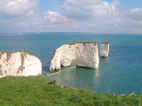
Old Harry Rock stacks Chalk stacks located east of Studland, below the cliffs at Ballard Down. The cliff is chalk with bands of flint and have been reduced over centuries by the sea. The downland habitat is home to a variety of chalk flora which is complimented by many species of butterfly including Chalkhill Blue and Adonis Blue.
Poole Harbour
Poole Harbour and quay is 3 miles of golden sands.
A large natural harbour, at it's entrance is Sandbanks where it's chain
ferry takes passengers across to the Isle of Purbeck and in it's centre
Brownsea Island,
Sandbanks A small piece of land jutting out at the opening of Poole Harbour is the Sandbanks peninsula. Three miles from Poole town centre. Sandbanks beach is 5 kilometres of golden sand and a Blue Flag beach popular with swimmers and bathers during the summer months. Watersports and other activities also take place. It is connected to Studland via a chain ferry, the Sandbanks Ferry which takes both car and foot passengers across the mouth of Poole Harbour.
Sandbanks to Bournemouth (6 miles) From Sandbanks you get to pass the chines of Flag Head, Canford Cliffs, Banksome and Alum, before getting to the beaches at Bournemouth and Christchurch Harbour. Bournemouth The sandy beaches at Bournemouth are popular with tourists. You could take a ride on the cliff lifts at either end to get up to the main town centre or take time out at the Oceanarium on the seafront.
Bournemouth to Mudeford (6 miles) This part of the path takes you along the east cliff through to Boscombe, the next part to Southbourne takes you past Honeycombe Chine and over 2 miles of grass cliff top and the remains of sand dunes which is home to sand lizards. From Southbourne to Mudeford you go over Hengistbury Head where you can get panoramic views of the coast and Christchurch Harbour before taking a walk along a beach lined with 300 picturesque beach huts, which are unique in that they can be slept in overnight from March to November each year, onto Mudeford.
Mudeford to Mildford on Sea (8 miles) Make your way along the shoreline and past Highcliffe Castle to the seaside town of Milford on Sea and on to Hurst Castle Spit at the end of which is Hurst Castle.
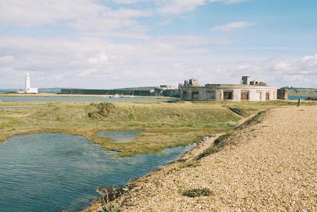
Hurst Castle One of Henry VIII's artillery forts built at the end of a long shingle spit at the went end of the solent to guard the approaches to the Navel Dockyard at Portsmouth. Charles I was imprisoned there in 1648 before being taken to London for his trial and execution. During WWII it was manned with coastal gun batteries and searchlights. It is now owned by English Heritage.
Hurst
Castle and the Lighthouse
Milford on Sea to Lymington (7 miles) As well as being the end
of this walk, it is also the start of the
Solent Way Path.
|
|||||||||||||||||||||||||||||||||||||||||||||||||||||||||||||||||||||||||||||||||||||||||||||||||||||||||||||||||||||||||||||||
|
Please let us know any other information that we can add to the Grid(s) or page and any errors that you discover. Before making a long trip to any location it is always wise to double check the current information, websites like magazines may be correct at the time the information is written, but things change and it is of course impossible to double check all entries on a regular basis. If you have any good photographs that you feel would improve the illustration of this page then please let us have copies. In referring to this page it is helpful if you quote both the Page Ref and Topic or Section references from the Grid below. To print the planning grid select it then right click and print the selected area. Please submit information on locations you discover so that this system continues to grow. |
|
||||||||||||||||||||||||||||||||||||||||||||||||||||||||||||||||||||||||||||||||||||||||||||||||||||||||||||||||||||||||||||||
. |
|||||||||||||||||||||||||||||||||||||||||||||||||||||||||||||||||||||||||||||||||||||||||||||||||||||||||||||||||||||||||||||||
|
|||||||||||||||||||||||||||||||||||||||||||||||||||||||||||||||||||||||||||||||||||||||||||||||||||||||||||||||||||||||||||||||
|
|
|||||||||||||||||||||||||||||||||||||||||||||||||||||||||||||||||||||||||||||||||||||||||||||||||||||||||||||||||||||||||||||||