| Home | Newsletter | Locations | Diary |
|
Indexes |
|
|
|
|
|
|||||||||||
|
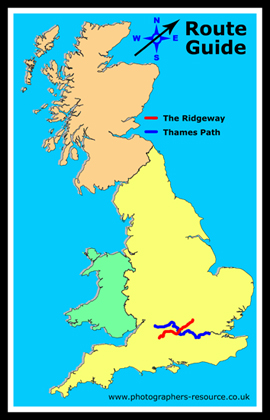
This route guide is in 3 parts:-
a Neolithic chieftain burial tomb, the
Uffington
White Horse , I first walked the full
length of this path, well before it became a National Trail, and I like many
others at the time included the section of the Icknield Way up to the beacon,
so it was a sensible decision to extend the National Trail version beyond what
was then the walkable part of the Ridgeway, to the beacon, although taking a
different route. In more recent years
I have revisited sections of this path.
National Trails
Most if not all of the Ridgeway was a wide trackway, that two carts could pass at any point without difficulty. Back when I first walked it all of the Ridgeway could be driven with a Landrover. In recent years some trees and hedging have been planted in some parts and some landscaping done that has made these sections more of a pathway, in some places adding a slight winding effect rather than a straight trackway following the high ground. Recreational vehicles, motorcycles etc are allowed along parts of it but much of it is no longer accessible to any vehicles and in most areas there are obstacles as well as it being illegal now to drive it. Some parts got very muddy and broken up and since it has become a National Trail, restoration has occurred, and its far easier to walk along than it was historically. All the major features are accessible within only a short walk from access points, and there are a large number of car parks, varying from a place to park to larger sites. In mediaeval times the Ridgeway formed part of a route used by drovers taking livestock from the West Country and Wales to markets in London and the home counties. Prior to the Enclosure Acts of 1750, the Ridgeway existed as an informal series of tracks across the chalk downs, chosen by travellers based on path conditions. In some places, particularly across Salisbury Plain, there is evidence remaining of multiple routes. In many parts of the country, but I am unaware of any relating to the Ridgeway, Roman roads in places were I believe placed upon some of these old trackways. They often run parallel to remaining ones and entrances of stone circles that predate the Roman roads have entrances that line up with far more Roman roads that would have come about by other means. This suggests that many of these were straight trackways. The Ridgeway generally flows in gentle curves, to follow the landscape but straight compared to the roads that developed later. Some suggest that these trackways were positioned or ran so as to join up the settlements in the earthwork castles along its length, but I would suggest this is not the case as only some are on the route. Instead I think they were used as bridges did not exist and these were generally dry routes, other trackways, Roman roads and other developments often being associated with fording places or the places where rivers could first be crossed. This idea is also supported by the route of the Icknield Way, that is later than the Ridgeway, and is not built along the ridge or highest point but just above the spring line. Preparing for your journey Although as a National Trail the Ridgeway Path is fully signposted, and is in most places obvious, it is always a good idea to both look at maps of the route ahead of your journey and take a map with you. In the information in this page I have given grid references throughout, and in most places also links to online mapping services, that should pop up in a new window, with the point being looked at marked. Ordnance Survey maps 157 and 170 cover the route at a scale of just over an inch to the mile. If you are not going to purchase a map then I suggest you zoom back, and print out sections of the OS maps from Multimap that cover the areas that you are going to walk. Look particularly for any place where confusion may occur, such as where there are several trackways, the trackway changes direction and another trackway goes on and places where you leave a road onto a path or trackway. I always work on the theory that signposts could have gone missing or may not be obvious. Walking is also more enjoyable when you can identify what you can see and know where you are at all times. Within the page below and on linked location guides you have far more information on the highlights along the path, and there are probably more on this route than any other. I have linked to aerial photos in many places, which may give you a better idea of what is there. Google aerial photos are clearer and flow more smoothly and with far less delays than the Multimap versions, but Google mapping currently does not go down to the walking detail, so I would suggest you use the Multimap for looking at the route mapping wise and if you want to follow it from an Aerial photo then use the Google aerial photos. I use two screens, one with a map on and the second with an aerial view, allowing me to see both, and also helping me to identify the places I can see in the aerial photos. Views As the Ridgeway Path follows, for most of its route, a high trackway, there are excellent views, some of the best can be found at the castle locations, as well as from the beacon point where the path ends. Wildlife There is a lot of wildlife to see along this
route, and you pass by many
Nature Reserves on or near the Ridgeway Path,
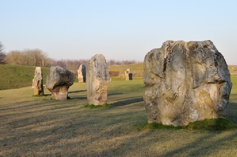
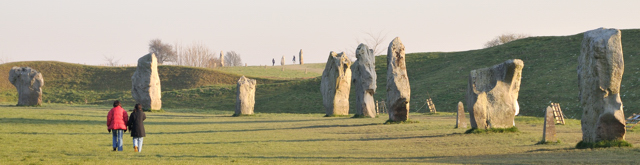
Avebury and the avenue, leading to the sanctuary and start of Ridgeway trail
|
|||||||||||
| Further Information
Nature Reserves on or near the Ridgeway Path
National Trails
http://www.nationaltrail.co.uk/ridgeway/
Please let us know any other information that we can add to the Grid(s) or page and any errors that you discover. Before making a long trip to any location it is always wise to double check the current information, websites like magazines may be correct at the time the information is written, but things change and it is of course impossible to double check all entries on a regular basis. If you have any good photographs that you feel would improve the illustration of this page then please let us have copies. In referring to this page it is helpful if you quote both the Page Ref and Classification from the Grids above. To print the planning grid select it then right click and print the selected area. Please submit information on locations you discover so that this system continues to grow. |
|
||||||||||
. |
|||||||||||
|
|||||||||||
|
|
|||||||||||